Wednesday May 11
Loop on the Eastern Branch of Carter Creek
Hike report by Nancy L.
Sixteen hikers met at the junction of Lloyd Stark and Boylan roads on a clear, sunny morning. We walked about a quarter mile up Boylan, crossing the east branch of Carter Creek to where we took a trail cut into the woods. The trail followed along the creek on the uphill side, quite high above the creek in a pleasant pine forest.
Hiking slightly uphill, we reached the remains of an old wagon road that took us gradually downhill. There was a nice view of the surrounding hills through the trees since the leaves were still sparse.
Upon reaching Carter Creek Rd., we decided to cross the creek to visit the remains of a “grand estate” on the other side. After a fun crossing of the major Carter Creek, we followed what appeared to be the old carriage road up to the ruin. Near the ruin the track was lined by big old trees and a line of old stumps, which were often used as fencing . The large foundation was in a field of vincas. Off a little ways to the south there was a considerable amount of rusted hardware.
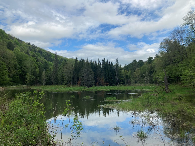
We returned to the creek and walked upstream until we reached another creek crossing , which took us back across the road to a trail up the other side of the east branch. After a trek through the pine woods along the hillside above the creek, we finally reached a beautiful pond surrounded by red pines. We successfully avoided the marshes as we took a trail around a second pond to Lloyd Stark Rd.for a short walk back to our cars.


View Nancy L & Randy’s photo album
Saturday May 14
Dabes Diversion Loop, Kennedy SF, Cortland County
Hike report by Jim
Thirteen hikers and 7 dogs met in Cortland County at the Dabes Diversion Loop trailhead to try out a partially new route for the group.
Overall it was a great hiking day, with warm temps, a lot of sun for our area, relatively few bugs and little humidity, with intermittent breezes.
The group set off on the Diversion Loop as we have done in the past; the loop is an enjoyable mix of flat and hilly areas, largely traversing pine woods. The needles underfoot always make an enjoyable hiking surface for me.
For the most part, there was very little mud on todays hike, which always makes for a nicer hike.
Soon enough we reached the overlook area where the FLT meets the Dabes Diversion Loop. We paused for a few quick photos, then turned southwest on the FLT. This is a new direction for our group hikes, as we normally turn east.
Soon we passed the Foxfire lean-to; a hiker was clearly in residence there, so we opted to leave the lean-to alone.
This section of the trail passes along several open fields such as the one at the Dabes trail junction, so it’s nice to look off to the side at the fields as you’re hiking along. There were no great hilly sections, but there were a couple of short, stream-fed muddy sections that some of our dogs found and wallowed in to great effect.
The original plan had been to hike at least part of the Lithuanian or Irish loop, but the group took almost exactly an hour to reach the junction of the Lithuanian Loop with the FLT. We will have to schedule this particular hike as a future longer summer Tuesday hike where we will check out those loops in more detail.
On this hike, after we reached the loop junction, we turned around and retraced our steps. This was an interesting experience as well for the group, as we’ve always experienced the Dabes Diversion Loop as part of the outbound part of a hike, and never as a return section of a hike. As with so many other trails, things look different in a reverse direction.
This hike counted as 4.53 FLT miles for those attempting to earn the FLT60 patch this year.


Sunday May 15
Jeep Trail & Trillium Walk, Shindagin Hollow SF, Caroline
Hike report by Jim
Sunday’s figure-8 trillium hike in Shindagin came into being by joining together parts of other Shindagin area hikes, with the intention of being able to check out the trilliums in bloom without dedicating an entire hike to a road walk in order to view the flowers along only a short distance of roadside.
When I first arrived on Shindagin before the hike, I drove the seasonal portion of the road down to the flatlands and found that the only remaining blooming trilliums were on hillsides along the lower parts of the valley, and mostly nowhere else along the road. I realized that the original route I had planned would result in the group seeing almost no blooming trilliums, so I modified the planned hike route.
Eighteen hikers and three dogs met at the trailhead; a 19th hiker arrived later and joined the group mid-hike.
We started by walking the Jeep trail in from Shindagin Hollow Rd. for a few hundred yards to where the FLT crosses the Jeep Trail; here the group turned onto the FLT and walked downhill to Shindagin Hollow Rd.
Trail conditions were dry, and hiking conditions were warm. Outside of the roadwalk portions of the hike, the bug situation was not a problem.
Once we were back on Shindagin Hollow Rd., the group walked up the road back to our cars, in the process passing a broad swath of trilliums that extended up the hillside as far as could be seen.
Back at our cars, we jumped onto the Shindagin Rim Trail, walking that to its opposite end higher up Shindagin Hollow Rd.
We then walked back down Shindagin Hollow Rd. to our cars, ending the hike with an almost perfect two hour duration.
There was quite a few other people enjoying the area, mainly bicyclists and dog walkers along the roadway.
After the hike, many members of the group met again at Brookton’s Market in downtown Brooktondale and enjoyed good food and more good conversation.
For those hikers attempting to earn their FLT60 patch this year, todays hike represents 1.2 FLT miles.