Report to Hikers May 30 – June 5

Monday May 30

Memorial Day Hike: Monkey Run Natural Area, Ithaca

Hike report by Jim

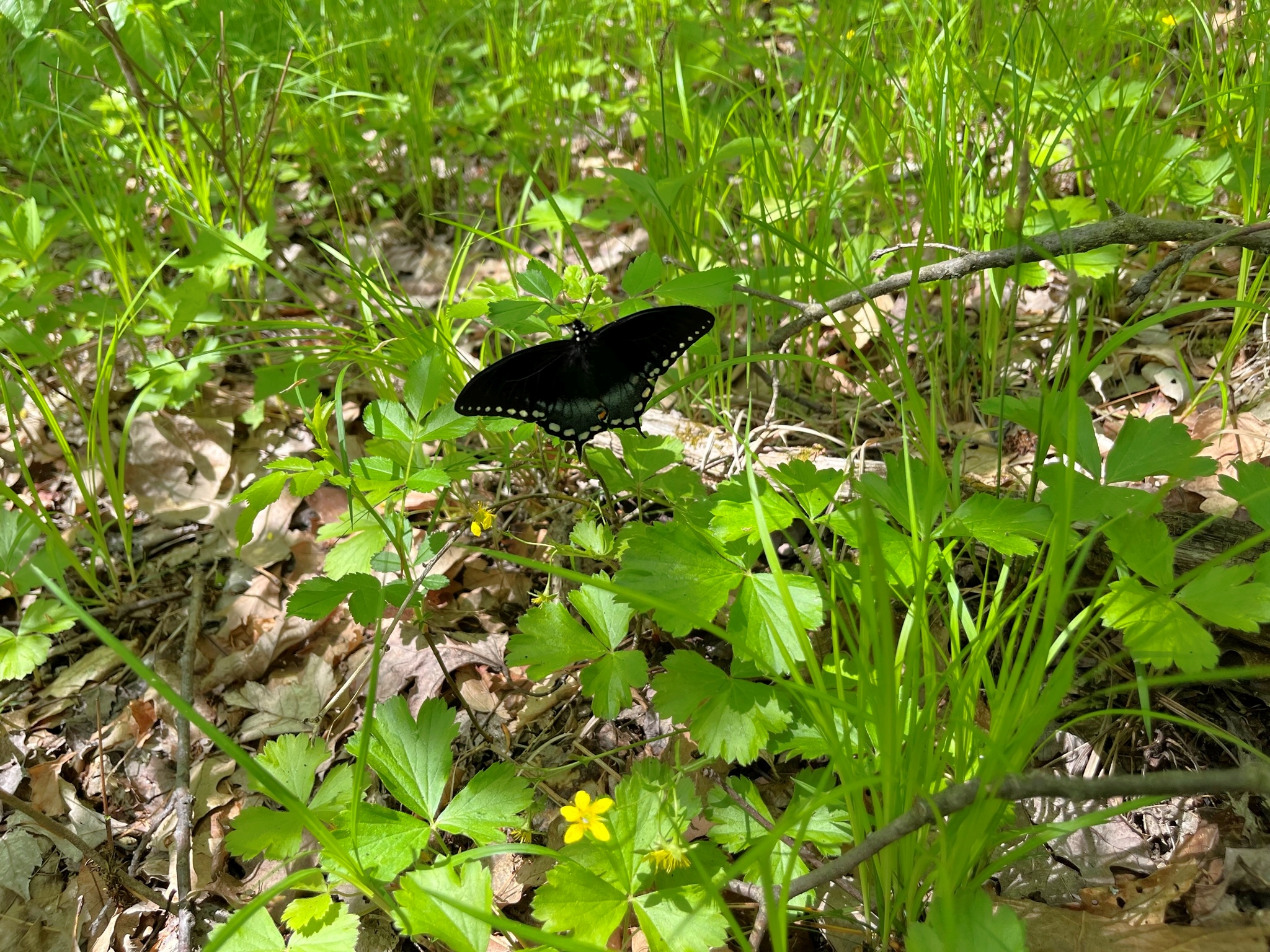
Twenty-four hikers and two dogs met on Hanshaw Rd. for a hike of the trail system around the north side of Monkey Run. The skies were somewhat overcast at the hike’s start, but  by the time the group had come out of the woods to skirt the open fields about halfway through the hike, the weather had  cleared and the fields were bathed in bright sunlight.

For the most part, we hiked a mix of red- and orange-blazed trails. The terrain was largely flat, although there are a couple of memorable stair climbs and associated elevation changes along the route. We diverted a couple of times along the way to check out viewpoints, such as the old bridge structure or the creekbed itself. Very early in the hike we were treated to the sight of a bald eagle swooping over our heads along the stream. I considered that the highlight of  the hike, and I know from hikers’ reactions that many other people in the group enjoyed the experience as well.

After reaching my planned turnaround point, we retraced our route as far back as the pavilion, bypassing the trails from the hike’s outbound leg. After we reached the pavilion area, we returned to our cars via the pavilion service road.

Photos by Cian

Photos by Mary W.

Photos by Leigh Ann

View Cian’s photo album

View Leigh Ann’s photo album

Wednesday June 1

Allan H Treman State Marine Park and Cass Park, Ithaca

Hike report by Jim

Twelve hikers and one dog met at Allan H. Treman State Marine Park for a hike of the marina trails as well as trails along the Cayuga Inlet and in Cass Park and the Black Diamond Trail.

It was a great sunny day for a hike, and the group made quick work of the paved and graveled paths in Treman Marina. The most memorable part of that section of the hike was witnessing some smaller birds defending their turf against a much larger hawk in the air above the group. The cottonwood trees were releasing their pollen during todays hike, and so the air and ground were full of the white cotton-ball like seeds drifting around us and accumulating in clumps on the ground.

It was a popular hike and bike day, and all of the trails we walked were heavily used, including by groups of summer program kids hiking and biking in and around Cass Park.

After leaving Treman Marina, we jumped onto the Waterfront Trail , which loops around Cass Park and its skating rink before following Cayuga Inlet inland.

After reaching the Children’s Garden, we crossed Route 89 and waked to the southern end of the Black Diamond Trail. We walked that trail for about 20 minutes before turning around and retracing our steps.

By now the sun was behind clouds, the temps had noticeably dropped a few degrees and the cooling breezes had picked up, an omen of the rain predicted for the afternoon.

Photos by Leigh Ann

View Leigh Ann’s photo album

Saturday June 4

Finger Lakes Trail and Lower Treman Park Trails

Hike report by Jim

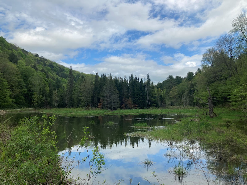
Seventeen hikers met in the parking lot at Shady Corners for a loop hike through lower Robert Treman State Park consisting of parts of the FLT as well as the Rim and Gorge trails within the state park.

Unbeknownst to me there was an all day 50K trail runner event in the area that included the FLT and parts of the Robert Treman park trail system as its course.

After arriving at the parking area I asked race personnel about numbers of runners, race duration, etc. It sounded as if the race in that part of the course was nearly finished.

Our hikers arrived, and we set off on the FLT under the bridge. By the time we reached the park access road we’d already had to yield to several runners and I realized that we had to modify our planned hike route or we would be yielding to dozens of runners throughout our hike.

The group walked through the lower park campground to the access road that leads to the YMCA pavilion access road. We found that road lined with dozens of cars, presumably belonging to runners. We continued to pass dozens of runners who were using the FLT footpath while we stayed on the access road.

Our hikers made our way to the Rim Trail, which was marked as part of the runners’ course but was being used mainly by day hikers as best I could tell.

The hike along the Rim Trail was enjoyable, the coolness of the forested trail a nice counterpoint to the heat we were finding in the more exposed sunlit areas of the park.

Along the way we found a couple of downed trees across the trail, something that would have been a most temporary occurrence that would have been quickly corrected by park staff in past years.

Reaching the small bridge that straddles the stream below Lucifer Falls,we crossed to the Gorge Trail and began an uneventful return trip to lower Robert Treman State Park. I’ve always found this part of the trail system to be among my favorite for this park, dating back to when I worked for the park system in the ’80s. This hike day was no exception and this part of the hike actually seemed to go faster for me than it has in the past.

We arrived back at our cars with after 2 hours and 10minutes, as expected. From there, many hikers went to the Hesse farewell party at Rogers house. Watch for a separate post about the party!

Photos by Randy S.

Photos by Cian
Photo by Leigh Ann

View Cian’s photo album

View Leigh Ann’s photo album

Sunday June 5

Taughannock Falls State Park

Hike report by Jim

Sixteen hikers and two dogs met in the parking lot on Jacksonville Rd. near Taughannock Falls Park Rd,. for a hike of the North and South Rim Trails of the park. I choose this meeting location because the park is now charging admission at the parking areas we normally use.

We did this hike in reverse direction from our usual route, first hiking down the North Rim Trail with stops at the overlook areas.

It was a great day to hike: sunny, warm, and clear. Park use by day patrons was high, so we were sharing the trails and overlook areas with a good number of other people.

After some quick pictures at the overlook area we continued down to the lower park area, where we hiked to the main falls observation area.

After several minutes there, we hiked to the base of the South Rim Trail for a return hike to our cars.

I found this direction for the hike to be a nice change from our normal counter-clockwise direction, so I’ll probably throw this into the planning for future hikes at this location.

A warm welcome to Mario and his dog on their first hike with the group.

Photos by Cian

Photos by Leigh Ann

View Cian’s photo album

View Leigh Ann’s photo album

Report to Hikers May 23 – May 29

Wednesday May 25

Six Mile Creek, Mulholland Wildflower Preserve and Businessman’s Lunch, Ithaca

Hike report by Jim

The Ithaca Hikers filled the parking lot of the Mulholland Wildflower Preserve on the morning of Wednesday May 25th.

This was our first hike of the preserve since construction wrapped up there earlier this year. Unfortunately, the planners didn’t include an expanded parking area, so we were once again forced to jockey car positions to make sure hikers could squeeze into the legal parking areas provided. Luckily for us, a couple of members of our group had hiked to the trailhead rather than drive, and there was only one other non-Ithaca Hiker at the preserve at hike’s start.

Once we got the parking situation sorted out, 19 hikers and one dog set off up the trail in the direction of Second Dam. Temperatures were mild at hike’s  start, although the high for the day was predicted to be above 80. We encountered a few other people, mostly dog walkers. The trail was in great shape, with only one detour early in the hike due to an unsafe trail condition. With the lack  of rain there was no mud on the trail, although the creek was still flowing well. Trees and undergrowth are now in full bloom, so we were sheltered from the heat of the day.

The group scaled the short hillside leading to the Second Dam access road, and from there it’s like a seasonal road walk to the overlook area for the reservoir. When we got to the second dam area, there was a lot of recovered trash along the road waiting to be picked up; probably the results of Ithaca College’s recent graduation parties.

At this point I had a brain cramp and led the group onto the blue-blazed trail that runs along the bluffs above the creek. This had been my intended return route after going to the reservoir overlook area. Hikers didn’t mind a few minutes spent rewalking some of the same trail, and soon we were at the overlook area. Once there, we reunited with some of our slower hikers who had skipped the blue-blazed trail in favor of the direct hike to the overlook area.

The reservoir itself wasn’t looking very impressive , and with the leaves out the view was not as good as it is some months of the year. After a quick group picture we turned around and started the return leg of the journey.

We returned to the parking area, where some finished the hike. Others crossed Giles Street and walked down into the stone amphitheater that is Businessman’s Lunch Falls (Wells Falls). After a few minutes spent there checking out the falls and the stone walls surrounding us, we returned to the wildflower preserve parking area.

A warm welcome to Jaime, on his first hike with the group!

View Nancy & Randy’s photo album here.

Saturday May 28

Loop Hike: Dove Trail to Finger Lakes Trail, Danby State Forest

Hike report by Jim

Twelve hikers and two dogs met in Danby for a hike of area trails. Rain had fallen overnight, but there was no rain falling at the start of the hike.

The group walked down Bald Hill Rd. toward Station Rd., turning into the woods to climb the Dove Trail just before reaching the intersection.

Hiking the Dove Trail was mostly uneventful as the group made its way down the trail, the sounds of conversation behind me a constant companion.

The group soon reached a fork in the route; I opted to keep the group on higher ground as we continued on the Dove Trail. I knew from the recent Abbott Loop group hike that the Abbott Loop section ahead had been extremely muddy, and I wanted to avoid as much mud as possible.

The pink-blazed  Dove Trail continued up the hillside, never getting particularly steep as it traversed the woods. A couple of minor stream crossings were easily dealt with. The undergrowth was in full bloom, and recent rains made the various shades of green we were passing through really “pop” visually.

Eventually we reached the farther junction with the Abbott Loop and continued toward the FLT. Here the terrain started a steep descent to the valley floor; with rain starting to fall intermittently I was worried that the roots underfoot would be hazardous on the steeper trail portions. There wre no falls on today’s hike despite the wet conditions

We came out at the FLT junction near Diane’s Crossing, and began the climb back up the hill via the FLT.

We stopped periodically for pictures, to point out the lean-to location to new hikers in the group, or just to allow the stretched-out line of hikers to regroup before moving forward.

Eventually we came out onto Bald Hill Rd. By now the rain was falling harder, although its true quantity had been concealed while we were under the forest canopy.

We crossed over Bald Hill Rd. and continued on the FLT to Comfort Rd. After we reached Comfort Rd., we road-walked back to our cars in what was now a steady, though tolerable rain. We arrived back at the cars at exactly the two-hour mark.

Warm welcome to Anthony and Matthew on their first hike with the group!

For those trying to qualify for the FLT60 patch, todays FLT miles were 2.3 miles.

Photo by Nancy H.

Sunday May 29

Potomac Rd. Trails, Finger Lakes National Forest

Hike report by Nancy H.

Twelve hikers and three dogs met on Potomac Rd. near the campground on a beautiful, sunny morning. The day was pleasantly warm, with lots of sunshine and a few clouds scattered across the brilliant blue sky. The trees are now fully leafed out, so it was cool and shady in the woods. Jack V. led the hike.

We got on the Potomac Trail and visited a pond that normally we’d walk around, but Jack had determined it was too wet, so we continued toward the Interloken Trail. Trail conditions were muddy, and we made good use of the installed boardwalks throughout the hike. (Even so, I somehow managed to come out of the woods with mud up to my knees!) The weather was so perfect and the company so enjoyable, I don’t think anyone minded a little mud. The trails here are level, easy walking, so we covered a lot of ground.

Wildflowers were abundant throughout the hike. At Foster Pond, we saw large tadpoles and tiny fish along the shoreline. We met a family that was camping near the pond and another family farther along, but didn’t encounter any other hikers.

We took the Interloken Trail until it was time to turn around. We retraced our steps and then got on the Backbone Trail, which took us back to Potomac Road and the cars.

Thanks to Jack for leading a delightful hike!

Photo by Nancy H.

Photos by Randy S.

View Cian’s photo album here.

Report to Hikers Week of May 16 – May 22

Wednesday May 18

Fischer Old Growth Forest, Newfield

Hike report by Jim

Fifteen hikers met in Newfield for a hike of the trail system within Fischer Old Growth Forest. It was a beautiful, warm morning, an omen of the hot and humid summer months ahead of us. Trail conditions were nearly perfect, with just a suggestion of mud along some of the streams on the hike.

We set off from the parking lot, quickly crossing the open fields before hiking into the woods below. The trail winds its way through some overgrown weeds before it enters the forest.

We began on the red trail, following that to the promontory with the dedication plaque for the forest. From there we retraced our steps and continued on the red trail until we reached the yellow-blazed trail loop.

This is the area that has the most appeal to me. As you hike down a former logging road, the forest floor below is relatively open, so you can see quite a distance across the flatlands. The larger old growth trees are in this area as well, which is something I always find enjoyable.

Completing the yellow loop we returned to the red trail and soon found ourselves navigating some steep inclines along the stream beds, first climbing down one side and then scaling the steep banks on the other.

The trail passes over some old stone walls before finally completing its loop back to  the trail where we started. On past hikes, the group has opted to turn around and retrace our route on the red loop to make the hike last a full two hours, but no one opted for this on Wednesday.

Returning to the open fields, we followed the blue-blazed loop that goes through the open fields back to the parking area.

I am hopeful that at some point an additional trail loop can be carved out of the remaining land within the forest; we often run short on hike time, as was the case on Wednesday.

Photos by Leigh Ann

View Leigh Ann’s photo album

Saturday May 21

Connecticut Hill, Newfield

Hike report by Nancy L.

Eighteen hikers (some new) and three energetic dogs met at the easy-to-access Tower Road location in Connecticut Hill Wildlife Management area.  We all parked along the east side of the road, allowing any traffic to pass without slowing. 

After a slight delay to collect the last-minute arrivals, we headed mostly southwest along dry, easily followed trails, with Nancy L leading the way.  We stopped at each trail intersection to keep the group together.  After about a half hour, one experienced hiker turned back, having accomplished his goal.  The others continued along a beautiful trail on the shaded north-facing slope before gradually turning south. 

We skirted a clear cut, following a new bypass trail, and reached a large pond.  We then retraced our steps on the bypass and elected to return via the more-travelled red trail.  This direct route back to the cars was welcome since the temperature was starting to climb into the high 80s and it was a slight uphill. 

When we were within sight of the cars, half the hikers opted to end the hike a little early, while the other half checked out a nearby loop for about 10 minutes. 

Overall, I think everyone was glad the hike was a little less than two hours…it was now HOT, and we were glad to be back to the A/C of our cars with all hikers and dogs accounted for.

Photos by Leigh Ann

Photos by Randy S.

View Leigh Ann’s photo album

Sunday May 22

Stevens Suspension Bridge – Cornell Natural Areas

Hike report by Jim

Seventeen hikers and four dogs met in the parking lot near the Stevens suspension bridge for a hike of area trails. The day was sunny, with breezes and a hint of humidity to come.

After crossing the suspension bridge, the group turned to the southwest, following the Cayuga Trail through the woods. I was particularly interested in doing this hike today to check out the trail conditions after the recent repairs to mitigate winter damage.

The undergrowth was in its full summer growth, leaving us a narrow but clearly defined path through the woods. Once we’d left the open areas, the coolness of the forest closed in around us.

We completed the first trail loop and emerged onto the Robert Trent Jones golf course, which was seeing a fair amount of use. We stayed off the greens, following the edge of the course along the treeline.

Eventually we cut through the woods and walked past the equestrian barns in the area of Bluegrass Lane. Several foals were out of the barns, and we paused briefly to check out the horses before continuing on the hike.

We circled the fenced fields and then returned to the woods and the Cayuga Trail, taking the red-blazed trails on the bluffs overlooking Fall Creek. The trees have now fully leafed out, depriving us of any clear views of the flatlands below. Eventually the trail led us via a spur trail to the trail network on the flatlands along the creek and back to the suspension bridge. Along this portion of the trail we passed over some of the repaired boardwalk that travels through the muddier areas; Jack V had participated in the repair.

We crossed the suspension bridge toward Forest Home Drive, then jumped on the blue, red, and yellow trails there. This took us in a second loop; along the way we were treated to a lively pair of woodpeckers who followed us briefly before flying on.

We arrived back at the cars with 10 minutes to spare, but overall it was a great hike on some trails we hadn’t been able to visit for a few months. I was glad to see the repairs and the trails being enjoyed by an assortment of people.

Photos by Cian

View Cian’s photo album

Report to Hikers Week of May 9 – May 15

Wednesday May 11

Loop on the Eastern Branch of Carter Creek

Hike report by Nancy L.

Sixteen hikers met at the junction of Lloyd Stark and Boylan roads on a clear, sunny morning. We walked about a quarter mile up Boylan, crossing the east branch of Carter Creek to where we took a trail cut into the woods. The trail followed along the creek on the uphill side, quite high above the creek in a pleasant pine forest. 

Hiking slightly uphill, we reached the  remains of an old wagon road that took us gradually downhill. There was a nice view of the surrounding hills through the trees since the leaves were still sparse. 

Upon reaching Carter Creek Rd., we decided to cross the creek to visit the remains of a “grand estate” on the other side. After a fun crossing of the major Carter Creek, we followed what appeared to be the old carriage road up to the ruin.  Near the ruin the track was lined by big old trees and a line of old stumps, which were often used as fencing . The large foundation was in a field of vincas.  Off a little ways to the south there was a considerable amount of rusted hardware. 

We returned to the creek and walked upstream until we reached another creek crossing , which took us back across the road to a trail up the other side of the east branch.  After a trek through the pine woods along the hillside above the creek, we finally reached a beautiful pond surrounded by red pines. We successfully avoided the marshes as we took a trail around a second pond to Lloyd Stark Rd.for a short walk back to our cars.

Ruined foundation surrounded by vinca. Photo by Nancy H.

Photos by Leigh Ann

View Nancy L & Randy’s photo album

View Leigh Ann’s photo album

Saturday May 14

Dabes Diversion Loop, Kennedy SF, Cortland County

Hike report by Jim

Thirteen hikers and 7 dogs met in Cortland County at the Dabes Diversion Loop trailhead to try out a partially new route for the group.

Overall it was a great hiking day, with warm temps, a lot of sun for our area, relatively few bugs and little humidity, with intermittent breezes.

The group set off on the Diversion Loop as we have done in the past; the loop is an enjoyable mix of flat and hilly areas, largely traversing pine woods. The needles underfoot always make an enjoyable hiking surface for me.

For the most part, there was very little mud on todays hike, which always makes for a nicer hike.

Soon enough we reached the overlook area where the FLT meets the Dabes Diversion Loop. We paused for a few quick photos, then turned southwest on the FLT. This is a new direction for our group hikes, as we normally turn east.

Soon we passed the Foxfire lean-to;  a hiker was clearly in residence there, so we opted to leave the lean-to alone.

This section of the trail passes along several open fields such as the one at the Dabes trail junction, so it’s nice to look off to the side at the fields as you’re hiking along. There were no great hilly sections, but there were a couple of short, stream-fed muddy sections that some of our dogs found and wallowed in to great effect.

The original plan had been to hike at least part of the Lithuanian or Irish loop, but the group took almost exactly an hour to reach the junction of the Lithuanian Loop with the FLT. We will have to schedule this particular hike as  a future longer summer Tuesday hike where we will check out those loops in more detail.

On this hike, after we reached the loop junction, we turned around and retraced our steps. This was an interesting experience as well for the group, as we’ve always experienced the Dabes Diversion Loop as part of the outbound part of a hike, and never as a return section of a hike. As with so many other trails, things look different in a reverse direction.

This hike counted as 4.53 FLT miles for those attempting to earn the FLT60 patch this year.

Photos by Leigh Ann

Photos by Randy S.

View Cian’s photo album

View Leigh Ann’s photo album

Sunday May 15

Jeep Trail & Trillium Walk, Shindagin Hollow SF, Caroline

Hike report by Jim

Sunday’s figure-8 trillium hike in Shindagin came into being by joining together parts of other Shindagin area hikes, with the intention of being able to check out the trilliums in bloom without dedicating an entire hike to a road walk in order to view the flowers along only a short distance of roadside.

When I first arrived on Shindagin before the hike, I drove the seasonal portion of the road down to the flatlands and found that the only remaining blooming trilliums were on hillsides along the lower parts of the valley, and mostly nowhere else along the road. I realized that the original route I had planned would result in the group seeing almost no blooming trilliums,  so I modified the planned hike route.

Eighteen hikers and three dogs met at the trailhead; a 19th hiker arrived later and joined the group mid-hike.

We started by walking the Jeep trail in from Shindagin Hollow Rd. for a few hundred yards to where the FLT crosses the Jeep Trail; here the group turned onto the FLT and walked downhill to Shindagin Hollow Rd.

Trail conditions were dry, and hiking conditions were warm. Outside of the roadwalk portions of the hike, the bug situation was not  a problem.

Once we were back on Shindagin Hollow Rd., the group walked up the road back to our cars, in the process passing a broad swath of  trilliums that extended up the hillside as far as could be seen.

Back at our cars, we jumped onto the Shindagin Rim Trail, walking that to its opposite end higher up Shindagin Hollow Rd.

We then walked back down Shindagin Hollow Rd. to our cars, ending the hike with an almost perfect two hour duration.

There was quite a few other people enjoying the area, mainly bicyclists and dog walkers along the roadway.

After the hike, many members of the group met again at Brookton’s Market in downtown Brooktondale and enjoyed good food and more good conversation.

For those hikers attempting to earn their FLT60 patch this year, todays hike represents 1.2 FLT miles.

Photos by Leigh Ann

View Cian’s photo album

View Leigh Ann’s photo album

Report to Hikers Week of May 2 – May 8

Wednesday May 4

Eastman Hill Rd. at the Tioga/Tompkins County Line

Hike report by Jim

Eight hikers met at the end of the maintained portion of Eastman Hill Rd. to hike the FLT. Light rain had started to fall as I was driving to the trailhead; this was sufficient to deter a few people from hiking, based on reports of arriving hikers who were not carpooling with anyone that day.

Based on the rain, I opted to alter our normal loop hike and omit the downhill abandoned section of Eastman Hill, which features a lot of loose shale and rock scree that I felt would be unsafe. Instead, the hike would feature two out-and-back sections of the FLT on either side of Eastman Hill Rd.

The initial short section of Eastman Hill from the parking area is usually an uneventful section that’s enough to get your pulse rate up but is an otherwise unremarkable stroll through land that is DEC property on one side and heavily posted private property on the other.

Cresting the short incline we met the FLT crossing and headed east. This short FLT section is always muddy, and today was no exception, with several short muddy bogs before the grade changes and we start an uphill stretch that takes us away from the mud.

As it happened, at this point we ran into a small contingent of CTC hike leaders who were pre-hiking their next section of the cross-county hike series. A convenient excuse to stop and catch up with each other as we don’t often see each other’s groups on trail.

Pressing on, we crested Eastman Hill and started down the opposite side. Here we encountered a heavy fog that obscured the valley below and created a very atmospheric effect on this section of trail.

We continued downhill through the various twists and turns until we reached the steep downhill leg that would have taken us to the abandoned portion of Eastman Hill Rd. that I had opted to avoid, so we turned around and retraced our steps back up the hill to the FLT road crossing we’d first turned on. Crossing Eastman Hill Rd., we continued west toward Heisey Rd. This segment is very overgrown when we hike it in the summer months, and it was nice to not contend with that overgrowth.

The trees were starting to leaf out and flowers were visible across the forest floor, along with a few more boggy muddy portions we encountered along the way.

After reaching Heisey Rd. we stopped and turned around, preferring a forest walk to the road walk alternative back to the cars.

Along the way on the last leg of the hike we checked out a small assortment of farm foundations that I’d never looked at on previous hikes here…Randy always has an eye for such things, and he said this was his first hike of this stretch of the trail.

By this time, the rain had stopped and the skies had visibly brightened.

We got back to the cars a few minutes past our normal hike duration.

This hike counts as four FLT miles for those who are trying to get their FLT60 patch.

This image has an empty alt attribute; its file name is Eastman-Hill-1.jpg
Photo by Nancy H.
This image has an empty alt attribute; its file name is IMG_2090.jpg


This image has an empty alt attribute; its file name is IMG_2388.jpg


This image has an empty alt attribute; its file name is IMG_2390.jpg


This image has an empty alt attribute; its file name is IMG_2095.jpg
Photos by Nancy L. and Randy O.

View Nancy & Randy’s photo album

Saturday May 7

Hoxie Gorge, Cortland County

Hike report by Jim

Eight hikers and three dogs set out from the parking lot at the dead end of  Hoxie Gorge Rd. for a hike of the FLT through Hoxie Gorge. While we were walking to the trailhead, two additional hikers arrived late and said they’d catch up to the main group but never did.

While on the trail we ran into  another hiker who started his hike from a different parking location.

This was the second hike our group has done at this location, and none of today’s hikers were here last year when this was one of our “farther away” Tuesday summer hikes. This resulted in some hikers arriving later than normal.

It was an overcast morning at the beginning of the hike. We entered the blue-blazed access trail from Hoxie Gorge Rd., and almost immediately we started finding blowdowns and trail damage from uprooted trees, which slowed our progress. According to signs at the trailhead, this section of trail was previously a section of the FLT until the FLT was rerouted  at some point.

The blue-blazed trail wound its way along the stream, making for some enjoyable scenery. It was a cool morning, but temperatures warmed up quickly as we made our way down the trail. Soon, people were shedding layers.

The blue-blazed trail intermingled with portions of the yellow-blazed SUNY Cortland McDermott Nature Trail (Trail Guide – SUNY Cortland); the colors prompted hikers to dub the trail “the Ukraine Trail.” Eventually the conjoined SUNY and blue-blazed trails met the current FLT footpath, and the group turned south.

Unlike our previous hike at this location, the undergrowth has not yet become overgrown, and the trail is extremely pleasing as it winds its way across several streams and through stands of tall hemlocks. Elevation changes are minimal, and water levels at the various stream crossings did not present a problem to the group.

Eventually the trail reached Hoxie Gorge Freetown Rd. We crossed the road and continue on the FLT for another 10 minutes.

We returned to Hoxie Gorge Freetown Rd. and retraced our steps, returning to the fork in the trail. From there we continued north, eventually locating our wayward solitary hiker along the way. We continued on for a few minutes more, then returned to the McDermott Nature Trail and took that directly back to the parking lot and our cars.

For the hikers attempting to earn their FLT60 patch, today counted for 4 FLT miles.

This image has an empty alt attribute; its file name is P5070278-1024x768.jpg
Photo by Jim
This image has an empty alt attribute; its file name is IMG_0084-768x1024.jpg


This image has an empty alt attribute; its file name is IMG_0085-768x1024.jpg


This image has an empty alt attribute; its file name is IMG_0086-768x1024.jpg


This image has an empty alt attribute; its file name is IMG_0087-768x1024.jpg
Photos by Casey

Photos by Leigh Ann

View Leigh Ann’s photo album

Sunday May 8

Upper Buttermilk State Park

Hike report by Jim

By my best estimate, this hike had 22 hikers and seven dogs. However, there were cars still showing up past the hike start time.

Sunday’s hike was a little odd, as my originally planned route around Lake Treman at Upper Buttermilk had to be altered on the fly a couple of times due to closed or damaged trails/ infrastructure.

I knew that the bridge at the top of the lake was damaged, but found on my check of the lake before the hike was that there was no good alternate way to cross the stream there.

My second plan was to cross at the dam and do things somewhat in reverse. The trail across the dam was still closed, despite all park trails being listed as open on the Buttermilk Falls webpage.

The group ended up hiking from Yaple Rd. along Treman Lake; from there we took the Bear Trail to the upper park entrance, jumped across West King Rd. The group took the gorge trail to the bridge at mid-stream, crossed over and climbed the Rim Trail back to West King Rd.

From there we retraced our route back to Yaple Rd and the cars.

Despite the morning starting out with low temps and frost on the fields on my way to the hike, by hike’s end the temps had risen significantly and the sun was out.

Welcome to Randy S., Janet, Sam, and Sam’s K9 friend, Sparkles, on their first hike with the group!

This image has an empty alt attribute; its file name is Upper-Buttermilk-spring.jpg
Photo by Nancy H.
This image has an empty alt attribute; its file name is Red-trillium-Randy-S.jpg
Photo by Randy S.

Photos by Leigh Ann

View Leigh Ann’s album