While in the Adirondacks, Jim and I climbed to the summit of Mt. Van Hoevenberg from the north side. The day was sunny, warm, and dry, and the bugs were nowhere to be seen. There was a reasonable amount of water flowing in the creeks we crossed.
There were only a few cars in the lot when we started the hike, but as the day progressed, we saw lots of hikers enjoying this well-engineered trail.
We logged about four miles over five hours, with a one-hour lunch stop at the top. Overall, it was a great hike, as the photos show.
Eight hikers met at the end of Tower Road on Connecticut Hill for a hike of the Bob Cameron Loop, with part of the Finger Lakes Trail included at the end as time filler.
Trail conditions on the Cameron Loop were good, with no blowdowns and very little mud encountered. This is always a concern, especially on the downhill portions.
A minimal amount of water flowed in the streams, but considering that it’s August we often see nothing in the streams this time of year.
Temperatures were warm, bugs were at a minimum, and the humidity, while noticeable, wasn’t as oppressive as it can be this time of year.
Hikers completed the loop with about 30 minutes to spare, so we crossed Tower Road and continued hiking on the FLT in a quick out-and-back to use up the remaining time.
Saturday August 12
Buttermilk Falls State Park, Ithaca
Hike report by Jim
Twenty-three hikers and a dog hiked into Buttermilk Falls State Park from Yaple Road. We made it to and from the La Tourelle trail before the rain started falling heavily. The remainder of planned route around Treman Lake and the Bear Trail was cancelled, and we returned to our cars.
About half of the hikers left the hike after reaching Yaple Road. The rest followed Casey toward the back trail entrance off Comfort Road to use up the remaining hike time once the skies cleared.
Welcome to new hikers Misa, Josh, Steve, and Nina on their first hike with the group!
Seventeen humans and one dog hiked the yellow trail on Logan Hill this morning. Most met at the Candor High School parking lot, and one hiker met the rest of the group after driving up the gnarly, extremely rutty and rocky seasonal road to the top and finally finding a place to park. This road is a fine, steep hike but not a fun drive in a car – and once you’ve started the seasonal part in a car, you’re committed.
The trail, but not the fields, had been trimmed since last Saturday, so wildflowers were everywhere. A little later in the season, the fields get mowed. The trail itself was not muddy, but it was clear that there had been a lot of rain the previous day. There were many, many mushrooms and amphibians (efts and tiny toads) on and beside the trail.
The weather was big, puffy, dark clouds against blue sky, so the hike was in sun and shadow the whole way. This is a good time of year to do this hike.
Fourteen of us set out on the Black Diamond Trail from the parking lot on Houghton Road at the back of Cayuga Nature Center’s property. We had a strong suspicion that others may have gone to the Nature Center itself, but those who found the map pin had a beautiful day for a brisk hike up the trail The fastest group made it all the way to the falls overlook center, but most of us settled for the railroad bridge with its own smaller falls. The water was running nicely there and at other spots along the way.
Though the day was not particularly hot, six of us wound up at my house for quick dip in the lake – very refreshing! Perhaps there will be another occasion when we are hiking on the west side of the lake and a larger group can come for swim.
Sixteen hikers and a single dog met on Braley Hill Road in Caroline, in the dual parking lots just above Bald Hill School Road. This was a loop hike combining parts of the blue, yellow, and red bike trails; a snowmobile trail; and a short section of the FLT.
Since I took over the group we’ve only done this hike once, last winter, and we came up short on time on that hike. On Friday I prehiked the area, checking out some of the bike trails we’ve previously bypassed, in an effort to improve our time on this hike as well as possibly include some of those other trails in a new hike for the group in parts of Shindagin State Forest that we’ve previously missed out on. I premarked today’s route with engineer tape due to the maze of trails – it’s easy to get lost on if not careful.
After an initial hike route briefing and group picture, we set off on the blue-blazed bike trails east of Braley Hill Road, trails that take the group through towering monoculture pines followed by a gradually descending arc of trail footpath that was gentle on the knees.
The bugs that hunted me down as a solitary hiker on Friday were not so obvious on Saturday’s hike. The only buzzing I heard was from the group of hikers behind me.
Eventually the blue-blazed trail intersects with both the FLT, which we initially bypassed, and a snowmobile trail that leads back to Braley Hill Rpad. After reaching Braley Hill Road, our route jogged briefly before taking the FLT west. In this area, there is some evidence of recent windstorms, which have sent a few trees crashing down, although nothing that we couldn’t work through.
After we reached the various red-blazed bike trails, the group turned north, working our way through a series of turns on different red-blazed trails that eventually terminated in a yellow-blazed section of trail we’ve hiked before. This final downhill section of trail brought us back to our cars only five minutes late – but that was still much better than a too-short hike.
It was only after returning to the parking lot that we ran into our first significant number of bike riders, unlike Friday when I repeatedly encountered groups of both bicyclists and other hikers on the trail.
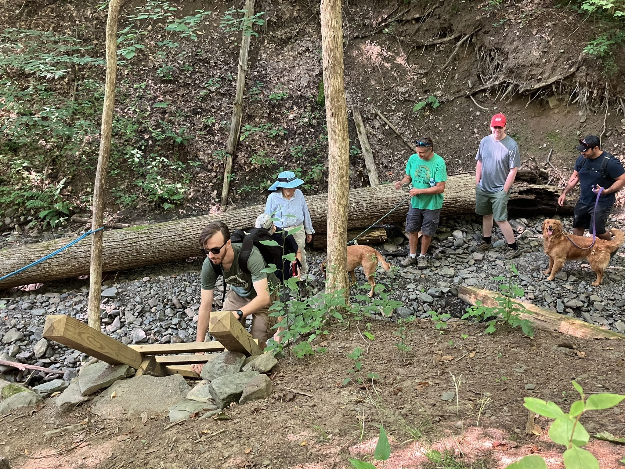
Nineteen hikers and two dogs met at Lower Creek and Hanshaw Roads for a hike of part of our adopted section of the Cayuga Trail to check on trail conditions.
The weather was sunny and warm, and bugs along the trail were minimal.
The group initially walked from the trailhead to Route 13, then we turned around and hiked the Cayuga Trail toward Freese Road as far as some of the open fields beyond the Cornell Outdoor Rec pavilion.
We skipped our usual stops along the creek, as time was a concern.
Trail conditions overall were good, and it looks as if we won’t need another trail maintenance day until early fall.
Welcome to new hiker Todd and his canine hiking partner, Lexi, on their first hike with the group!
Our party host Roger needs help with set-up on the morning of the 19th and break-down on the morning of the 20th. If interested in helping, please contact Roger at rogerbeck50@gmail.com.
As always, if you are attending the picnic you are free to bring food to share with the group.
Hiker Recognition:
On her recent trip to the high peaks, Ithaca Hiker June Meyer has completed all 46 of the high peaks. Congratulations June!
It was the Tale of Two Nancys. We started the Wednesday hike from the tower at Tower Road on CT Hill with 12 hikers, which happened to include two Nancys. At the beginning of the hike one of the Nancys went off to go forage for mushrooms with Betty and hike on some trails that could be more adventurous than the good old FLT that the rest of us took. Since we still had one Nancy, we were fine. You can imagine if there were two Caseys on a hike, one would really be more than enough.
I sort of facilitated the hike, with Greg being our hike leader and Tom being the sweep. Fortunately ,the Nancy who left was good enough to let our sweep know what was going on, so there was no missed communication there. That left us 10 hikers including, of course, one Nancy. We stayed with the FLT as an out-and-back hike and had a lovely hike. It was a little muddy but not bad for CT Hill, and it was just a little buggy but not as bad as what I often expect there. I logged 4.64 miles. And at the end of the hike we had 12 hikers show up which as you might imagine included both Nancys.
Photos by Nancy H.
Saturday July 22
Hammond Hill State Forest from Route 38 south of Dryden
There was some confusion about the starting point for this hike. The original meeting point was changed after it had been sent out, and some hikers didn’t realize this. For that reason, we have two reports for this hike: one from each starting point.
Hike report by Mark L.
The road goes ever on and on, down from the road where it began, and so our nine companions set out from the parking area at Star Stanton Road. It was a few hundred yards to the FLT tailhead, where we found two more Ithaca Hikers, who’d started from the other end of Star Stanton Road and who joined us for a 4.2 mile hike on a pleasantly cool morning. We found a variety of mushrooms in a rainbow of colors along the trail.
The trail had a few muddy spots but was mostly only damp. The forest was fragrant and alive with birdsong and the steady chatter of our (mostly) merry band.
On our way back, we found a geological marker at the base of a tree not far from the top of the hill and the microwave transmission tower. Our hike-leader-in-training missed a turn in the trail, but this was caught by the ever-watchful eye of more seasoned hikers. Two of our companions parted company at this point, and we returned to the beginning of our walk with the original nine. And whither then? I cannot say.
Photos by Nancy H.Photos by Mark L.
Hike report and photos by Leigh Ann
Roger and I arrived at the original trailhead for today’s hike, which in hindsight was at the opposite end of Star Stanton Road from the revised trailhead. Confused but happy to see each other, Roger and I decided to hike from the trailhead on Hammond Hill Road. We had a lovely hike in the woods from Trail 1 to Trail 6, then 5, then 4. When we arrived at Grand Central Station, we went east on Star Stanton Road a bit, then hopped on Trail 1 to return to the trailhead. It took us 2 hours, and we went about 5.15 miles.
Sunday July 23
Stewart Park urban hike, Ithaca
Hike report by Norm
TO THE LIGHTHOUSE
On Sunday morning, July 23, 13 people met at the little parking lot by the Cascadilla Boat House at the eastern tip of Stewart Park. Cayuga lake was serene, like an old woman peeling off her Covid mask at the start of a meal. A few seconds after I got there and started to say hi – this point often reminds me of the start of Shirley Jackson’s short story “The Lottery,” where the townsfolk greet one another and the reader thinks, if they think anything at all, that this is rather ordinary and meandering – Nancy H asked if I’d like to lead. I sprang at the opportunity.
We strolled a few yards, then Leigh Ann herded us to the shade and shot us while we were still in one group. One more person joined as we circled around the swan pond just north of the boathouse. We then flew like stones south along the mouth of Fall Creek.
We stopped at the purple martin house at 42.459559 -76.506900. I pontificated extemporaneously on the features, habits, and virtues of the martin house and its many noisy aerial denizens. The martins put on a good show. When we finished annoying them, we strode across the walkway to Renwick Wildwood and admired the verdant poison ivy.
Nancy asked if I’d like to do the hike report. I lunged at the chance to practice my creative writing like a territorial pit bull slicing the mail sack off a startled postman. (How’s that for vivid imagery, John Gardner?)
We looped through Renwick Wildwood, paused on the suspension bridge to gawk at a young couple paddle boarding with their small, long-haired, terrified dog (the only dog on this hike, other than the one in my imagination, which is still barking at that poor postal worker), took a gander at the golf course and followed Tom’s advice to roll along the paved trail, rather than bother the paying customers.
A family of osprey flew over, and a noisy group of them sat on a nest platform on the inlet edge of the golf course. We passed the whitewash under where the cormorants perch in the tall trees without casualties. The rough, overgrown jetty to the white lighthouse likely challenged some of the hikers, but all came through this lottery intact.
On the walk back to the golf course, we stopped to hear Roger say a few words about the reforestation project in the swampy woods. We left the many happy mosquitoes, skipped the Farmers Market (dunno where all the time went), and walked back to the cars. Our relaxing meander covered roughly 4 miles.
Photos by Nancy H.Photos by NormPhotos by Mary W.Photos by Leigh Ann
Ten hikers (plus one Hiker Emeritus) ventured two hours south to explore the gorge and waterfalls in Ricketts Glen. The warmth and humidity of the day were nicely countered by the sheltered depths of the gorge and the breezes generated by the waterfalls.
And falls there were! We passed 19, 10 of those twice because a rockslide-induced trail closure turned what might have been a 4.5-mile loop hike into a 7.2-miler that required some backtracking.
Recent rains made the falls spectacular torrents, filling the gorge with the sounds of rushing water and generating the mists that often made the many steep rock stairs wet enough to deserve a cautious descent.
The waterfalls were varied: some wide cataracts less than 20 feet tall, others narrower cascades tumbling nearly 100 feet. All were beautiful.
The group enjoyed a mid-gorge lunch and, later, the reward of a stop for ice cream on the return trip to Ithaca. A great day and a beautiful hike made the long drive well worth the time and effort — the destination is a winner!
Wednesday July 12
FInger Lakes Trail from White Church Road
Hike report by Jim
Although the day was sunny, it was cooler than what we’ve experienced recently. I arrived early at the parking lot and had an enjoyable prehike show put on for me by hummingbirds and bees as they darted among the various flowers bordering the parking lot.
In total, we had 15 hikers on Wednesday. We left the parking lot of White Church Road and crossed the open fields toward Wilseyville Creek. The fields were somewhat overgrown and in need of a good trim. (I’m hoping that everyone did a good tick check after they got home!) Reaching the treeline gave us some welcome relief from the direct sunlight and saved some members of the group from spontaneous combustion.
The group initially followed the rerouted FLT toward the White Church/ Coddington Road intersection. When we arrived there, some hikers decided to check out the remainder of the FLT reroute as far as the Eberhard Preserve. The main group of hikers retraced our steps along the FLT until we reached the old FLT footpath.
Before the FLT was rerouted last year, I received permission from the property owners to continue to walk the old footpath on a limited basis. Today, we walked the old trail until we reached an open field near Ridgeway Road, where we turned around.
Some of our hikers did a trim job of this section a couple of years ago, and the old trail is quickly becoming enveloped by greenery. The owners are keeping parts of the trail cleared for ATV use, but I can see a day in the not-too-distant future when the section along Wilseyville Creek will require a good amount of bushwhacking for anyone trying to walk it.
On the return journey, we reacquired our subset of exploratory hikers and retraced our route back to the parking lot.
Today’s mileage was 4.5 FLT miles for those trying for their FLT 50 patch.
A warm welcome to Andy on his first hike with the group!
Photo by Nancy H.
Saturday July 15
Kennedy State Forest, Dryden
Hike report and photos by Jim
Thirteen hikers met on Daisy Hollow Road for a loop hike of portions of the FLT and Swedish Loop in Kennedy State Forest.
There was a strong mix of sun and shadow along the route as we left the trailhead and entered the woods. Despite recent rains, the trail surface was generally soft – but there was not as much actual mud as I expected at the start of the hike. The roots along the footpath, as always at this location, were the real hazard for hikers who weren’t attentive to foot placement as they moved down the trail.
Humidity was ever present, as was a steady supply of flying insects. We encountered a couple of recent blowdowns across the trail that were reported to the trail maintainer and CTC sawyers.
Historically on this hike, we always seem to get back to the cars about 15 minutes early, and so today I tried to reverse our loop of the FLT and Swedish Loop portions to add some time. Unfortunately the change didn’t work as planed, and we still got back to the cars earlier than normal. I will have to experiment with some changes to the route for future hikes here to get us up to a full two-hour hike duration.
My estimate of FLT miles would be around 4.0 for the FLT50 patch folks. (I haven’t done a map or GPS verification on the miles to confirm that.)
Sunday July 16
Lime Hollow Nature Center, Cortlandville
Hike report by Jim
Twenty-four people met on Gracie Road for a hike of the Lime Hollow Nature Center. The day was sunny, with rain expected only after the end of the hike.
Hikers set off down the Lehigh Valley Trail, then circled the High Vista Loop before returning to the Lehigh Valley Trail and on to the nearby Hermit’s Way. After crossing a bridge or two, a turn onto Fenway brought the group back to the Lehigh Valley Trail and a quick return to the parking area.
Some of the group cut their hike short here, while the remainder continued to Maple Run for an out-and-back visit to the Chicago Bog.
The rain started to fall within minutes of the hike’s end.