Finger Lakes Trail from Schuyler County Veterans Memorial Park, Alpine
Hike report by Nancy Lorr
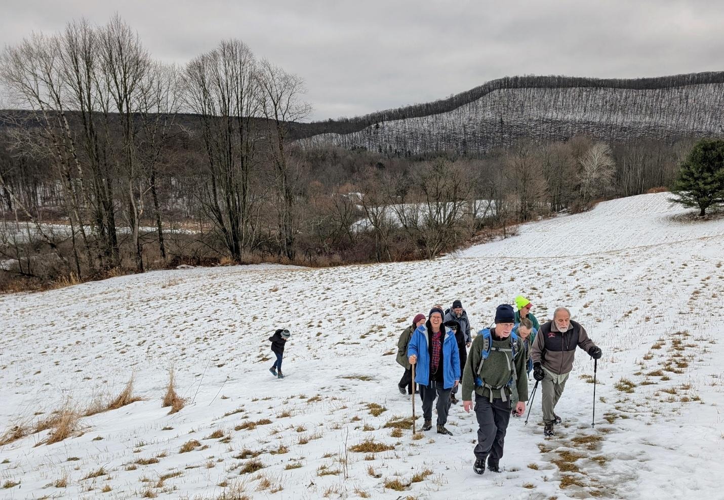
19 people and one dog gathered in a newly plowed parking area at Schyler County Veterans Memorial Park. I was fortunate to find an individual who was a member of the family that donated the land for the park who agreed to plow the parking lot for us. After some discussion we decided to hike East from there on the Finger Lakes Trail although the snow was about 3 inches deep. When we reached route 6 we crossed over the outlet creek of Cayuta Lake on the road bridge and turned onto Gulf Road a short distance to the continuation of the Finger Lake trail which took us along the edge of the picturesque snow covered Cayuta outlet. We hiked for about 2.5 miles total in the easterly direction and then retraced out steps back to the cars.
Hike report by Leigh Ann
After several weeks of wind chills too unfriendly for hiking, nineteen hikers and one dog on a leash met at the parking lot of the Schuyler County Veterans Memorial for a hike on the FLT. The group voted to head east toward Gulf Road and Hendershot Gulf.
We made it about 2.15 miles from the trailhead before turning around. There was less than 200 feet of elevation gain on this hike. However, even though only 1/4 mile was previously untrodden by feet or snowmobiles, it felt like about 500 feet of elevation gain with the 6 inches of snow on the ground. Still, it was a great hike for the many of us who’d been experiencing cabin fever.
And we discovered a treasure that may have been hidden in the snow: a child-sized, rather nice golf club. Norm claimed it and had a fun time whacking snow off the bridge with it.
Eighteen hikers were on this sunny and warm-for-February hike. We took our standard route west from the suspension bridge, around the golf course, and on the roads through the horse farm. (I spotted 22 horses today.) Then we headed down into the woods and along the top of the bluff, went town steps to the bottom of the bluff, and paralleled the creek to cross the suspension bridge again.
At that point, six hikers opted to go back to the cars, and the rest added a bit of mileage on the short red and blue trails on the north side of Forest Home Rd. The round trip was about 4.15 miles.
On Saturday, ten diehard hikers were undeterred by frigid temperatures—and an unexpectedly unplowed parking lot.
I hadn’t had time to check the location before the hike, but since we’ve hiked this route in previous winters I didn’t expect any issues. I was wrong. I arrived at the Tappan Mitra parking lot to find that it hadn’t been plowed since last weekend’s storm. One hiker was shoveling out the entrance to the lot, and a couple of cars had arrived and made their way through the deep snow to park. Several hikers grabbed shovels and continued clearing out the snowbank by the road. More shovels came out as more hikers arrived, and eventually we cleared enough so that all hikers made it into the lot with no problems.
But, as everyone was doubtless thinking, making it out of the lot would be another issue altogether.
We left on time for an out-and-back hike on the Finger Lakes Trail, from where it starts in Lower Treman on its route up the hill toward Newfield. There was just one set of footprints ahead of us in the deep, powdery snow. The sun came out from time to time, and occasional snowflakes sparkled in the air. It was cold, but there was no wind, and most of us had already warmed up with our shoveling exertions.
On the outbound leg, hikers commented on what a beautiful morning it was and how glad they were to be out of the house after the past week’s weather.
Past the picnic area, the only footprints were from deer. We made our way through snow that was about five inches deep. The group made the decision to turn around seven minutes early—realizing it would take some time to get everyone out of the snowy parking lot.
We made good time on the return leg and arrived back at the lot about 20 minutes early. Hikers started shoveling again. The first car had trouble getting up the slope to the road, so shovelers worked to clear a track down to the gravel, or as close as possible. We then put down salt to provide traction. After that, the cars left the lot one by one.
Not only did we get a bonus upper-body workout, I was impressed by the way no one complained about the condition of the lot. Everyone treated it as a problem to solve together—with maybe a touch of unexpected adventure. The next time we hike here in winter, though, we should follow the example of one hiker, who saw what we were doing and decided to park her car in the Lower Treman parking lot, then walk back to meet us.
A warm welcome to Karen on her first, chilly hike with us.
The hikers set off from the parking area, walking the access road to Stevenson Rd. Once across Stevenson Rd the Dryden Rail Trail is unplowed, with only a narrow band of beaten snow that is used by all trail users. The trail crosses a couple of bridged portions of Cascadilla Creek before arriving at Game Farm Rd.
Once the group crossed Game Farm Rd we were now on the east Hill Recreation Way, a paved walking route that is both plowed and salted; this feature is why I selected this hike location after the snowfall of the last week.
The East Hill Rec Way passes along some additional sections of Cascadilla Creek, the MacDaniels Nut Grove, and several Cornell University buildings before arriving at the old rail trestle that passes over Pine Tree RD.
After an hour the various hikers turned around and re-traced their route back to the cars.
We shared the Rec Way today with several joggers, dog walkers and other pedestrians.
Hike leaders please check the Google calendar to claim any hikes that you wish to lead in February.
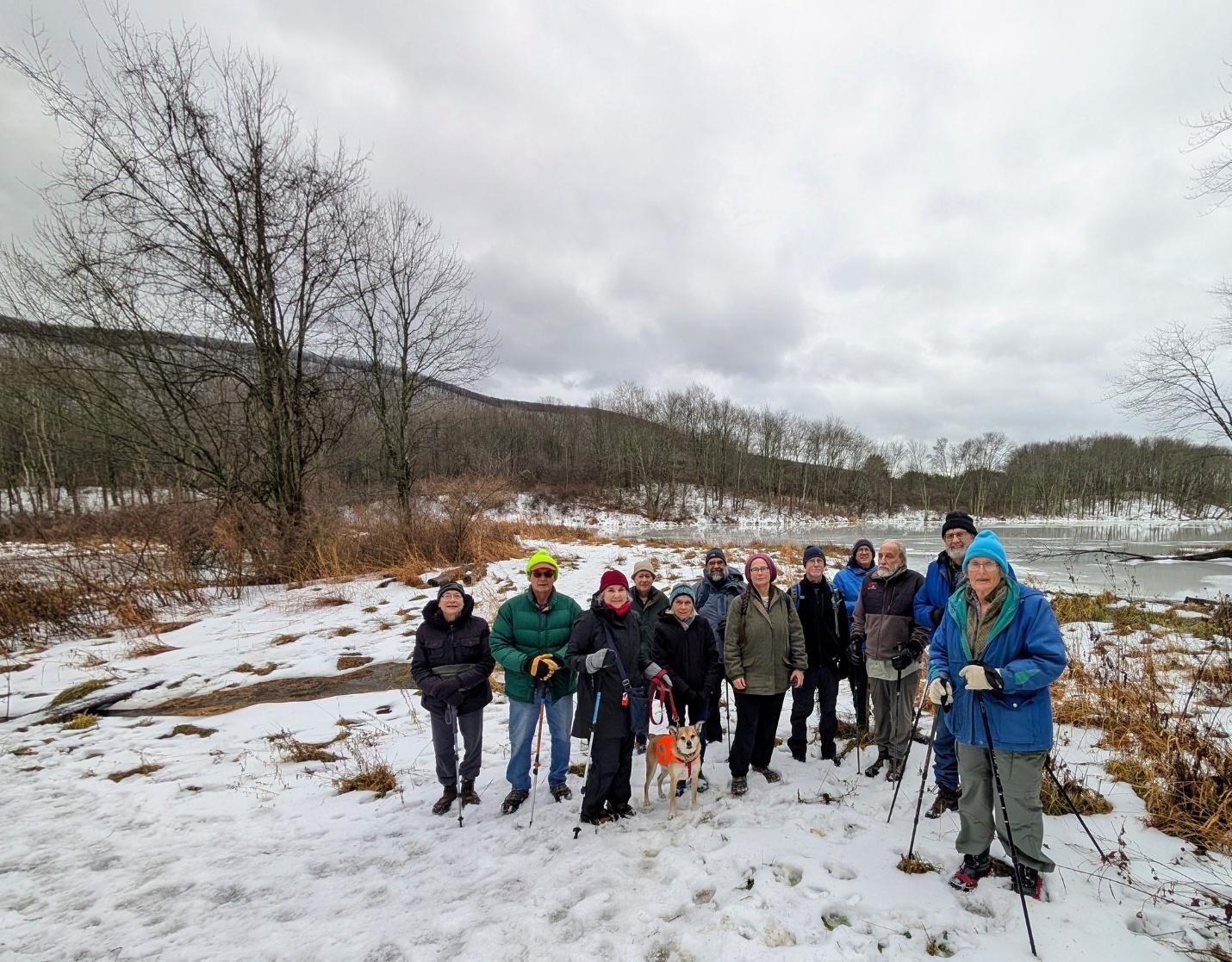
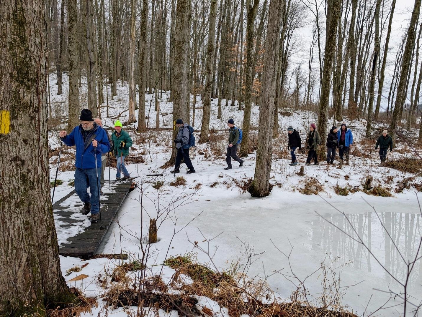
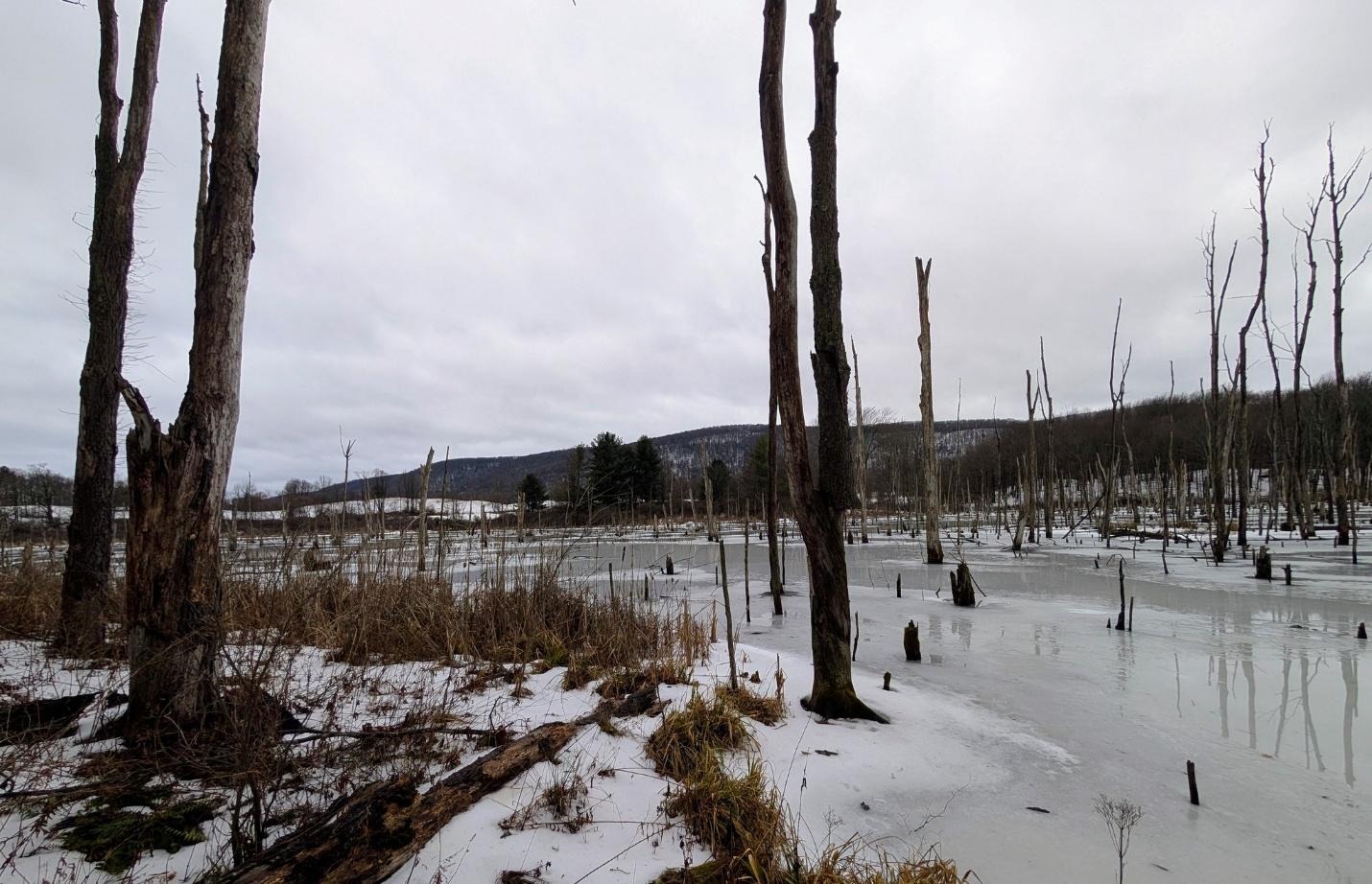
18 hikers and 2 dogs gathered at the corner of Lloyd Stark Boylan and Connecticut Hill Roads for an exploration of un marked trails on Rowell Hill. a glimpse of the frozen beaver pond was taken before returning to the cars
Photo by Nancy Lorr
Saturday, January 17
Ekroos Rd. at the Tompkins/Tioga County Line
Hike report by Jim
Twelve hikers met on Ekroos Rd on the Tioga/ Tompkins County line for an out-and-back road walk led by Nancy H. This is hike # 57-14 on our list of regular hike locations: https://www.ithacahikers.com/hike-57 .
Weather conditions were good, with cold temps and light snow flurries at the beginning of the hike. By the end of the hike the snow had stopped, and the sun was shining through the cloud cover.
In the past, Ekroos Rd has tended to be a reliable winter hike location, plowed for the two houses along the way but otherwise a very icy road surface. Because of this everyone was wearing foot traction during the hike; the foot traction proved to be unneeded until the very end of the hike where the road transitions to a seasonally maintained surface. The rest of the route was well plowed, and we could see where multiple blowdown trees across the road had been recently chain sawed to clear the lane of travel.
Much of the outbound leg of the hike is a gradual downhill, with the last section approaching 76 Rd to be quite steep. Along the way the road weaves in and out of Tompkins County, the road bearing three different names along the length of the route.
The road passes over several streams, which were quite active today. The road is also bisected by a snowmobile route, but we saw no snow machines or any vehicular traffic on the road today. We did see one other solitary road walker like ourselves during our hike.
There was one section of trees lining the road that’s had a broad swath of tree clearing since our last hike here. I’m not sure if this was on state forest or private land
The faster hikers on the group made it as far as 76 Rd, which they tapped before turning around and re-tracing their steps.
Photo by Jim
Hike report by Nancy H.
A dozen hikers met on Ekroos Road, which runs along the line between Tompkins and Tioga counties, for a wintry road walk. Ekroos Road, which runs alongside a gorge, is a delightful three-season hike. In winter, the bare trees allow some beautiful views into the woods and across fields. Part of the road is seasonal, so there’s little to no traffic, and at times the road seems more like a wide trail through the woods.
Light snow was falling as we set out. The road was somewhat icy, so foot traction was needed. This hike goes downhill for an hour (with some leveling off about halfway down), which means the return leg is a long, steep uphill climb. Because it’s an out-and-back that stays on one road, everyone could hike at their own pace. As we were returning to the cars, the sun emerged from behind the clouds that had filled the sky for most of the hike. A few hikers got back to the cars early, so we kept going in that direction until the full two hours were up.
Twenty-two hikers met on Daisy Hollow Rd in Cortland County for a lollipop hike on parts of the FLT and the Swedish Loop trail in James Kennedy State Forest led by Casey C. This is hike # 40-4 on our list of hike locations: https://www.ithacahikers.com/hike-40.
There are several FLTC map sheets that cover the area of today’s hike. The map sheet with the most detail is map sheet ” The Swedish Loop Trail”, available in paper or electronic formats at : https://fingerlakestrail.org/…/purchase-individual-maps/ . Sale of the map sheets helps to defray the on-going costs associated with trail maintenance.
Today’s hike took us through an area where we’ve had several recent large blowdowns across the trail, but they’ve all been dealt with by trail maintainer Alex Gonzalez, who does a great job maintaining this section of trail.
While Tompkins County hasn’t seen much snow depth in recent days, Kennedy Forest still has a decent quantity of hard crusty snowpack along the trails we hiked today. This particular hike is always known for the many roots that run across the footpath that can be a hazard to hikers in the winter and rainy summer days. Today we took our time on the outbound leg, carefully picking our way along the trail that runs for much of the hike along and across a nice running stream.
About a mile into the hike, we reached the first intersection with the Swedish Loop trail. We continued on the FLT until we reached the yellow blazed Stockholm Short Cut Trail. This trail cuts back across the stream to the Swedish Loop Trail.
The group took the Swedish Loop Trail back to the FLT. Traditionally this hike always runs around fifteen minutes short, so in an effort to make up that time Casey turned the group around and returned to the FLT along the Swedish Loop and Stockholm Short Cut Trail.
Once back at the first intersection of the FLT and Swedish Loop Trail the group returned to our cars without incident. On the return trip the trail surface was much easier to traverse now that the surface has beaten down. We got back to the cars at our normal hike duration thanks to Casey’s route modifications!
We did encounter one small group of day hikers on the trail but otherwise has the hike to ourselves.
Warm welcome to John, Brenda and Fiona who joined the group for their first hike today!
For those hikers who are tracking their FLT miles for a 2026 FLT50 or FLT100 patch, todays hike included three FLT miles.
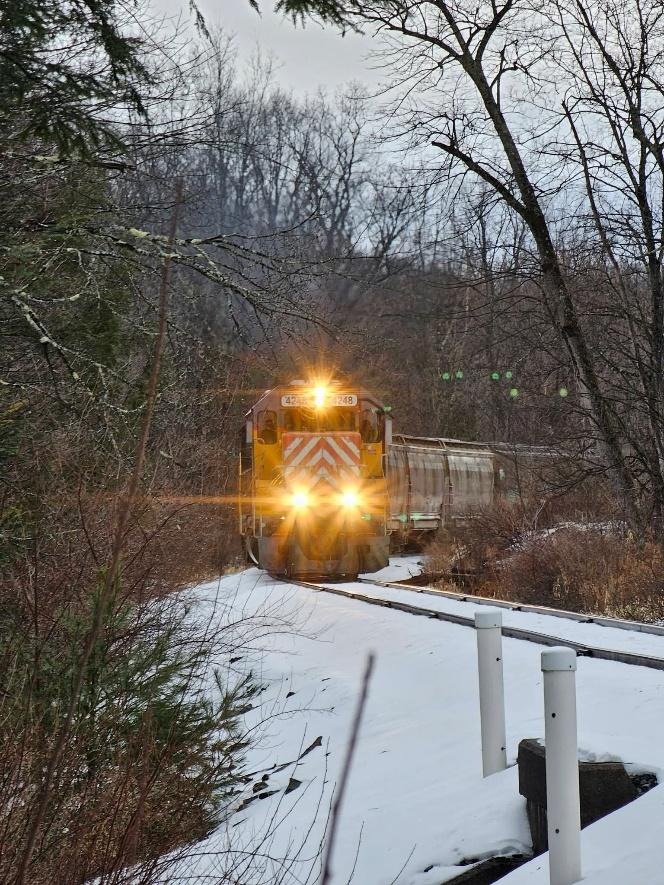
On Wednesday, January 7, thirteen hikers and 2 dogs met at the beautiful Lyndsay-Parsons preserve for a hike with the Ithaca Hikers. The weather cooperated as the drizzle stopped shortly before the hike began.
One dog (and owner) left early due to cold feet. The rest continued on through the fields and woods, admiring the frozen ponds and vistas. We even got to see a freight train pass as we crossed the tracks the second time. We finished in just under 2 hours as we were somewhat slowed down by the slushy snow.
Photos by Mark Sussman
Saturday, January 10
Upper Buttermilk State Park, Ithaca
Hike report by Nancy Lorr
28 hikers and one dog gathered to hike this morning. The trails were sill quite icy though possible with foot traction and slowly improving with several days above freezing. We took the Bear Trail to Lake Treman. Then we took the trail skirting the West side of the “lake/bog/lagoon”. After visiting the impassible inlet we took a side trip to Yaple road before returning either by the Bear trail or the access road.
Hike Leader Nancy L led todays hike and with the help of Randy O planned and prepped the location for our post-hike annual winter picnic at upper Buttermilk Falls State Park. I’ll leave the regular hike report to Nancy, but I’ll make a quick post on the picnic part of the day, as I helped set up and break down the picnic location at the small FLT-type lean-to just inside the upper park entrance
Randy, Roger, Bud and myself set up the tables, got the fires going in two of the park BBQ hibachis as well as a larger firepit. By the time the hikers were coming back from their out-and-back hike to the top of Treman Lake, we had the first course of meat on the grill and the various foods that hikers had left us prior to the hike laid out.
I was a little surprised to see the tree cutting going on in the upper park. See photo. The sawyer work has blocked about half of the normal parking spaces in upper Buttermilk, so out group today had many cars parked along the shoulder of the entrance road
Photo by Jim
Nancy L estimated that she had 28 hikers and a single dog on the hike. For the picnic we had three distinct waves of hikers at the tables. The first group were the people from the hike. After they had filtered away from the tables we had a second and third wave of hikers arrive with their own food contributions to the meal.
Towards the end of the event Randy estimated that we had an additional thirty hikers show up.
The temps were cool but tolerable. The walls of the creek bed had some sheets of ice still present despite somewhat warmer recent temperatures. Water was flowing quite well in the creek bed. Rain started falling at about 1:30 PM which was the cue for the hikers to pack up and call it a day.
I know that there were a couple of new hikers listed on the Meetup RSVPs. New-to-the-group Ross B was the only new hiker who I met.
One of the new hikers lost a mitten on the hike; that mitten has been located. Someone left a small blue igloo cooler at the lean-to. I have both items in my car, if the owners want to get ahold of me to get their property back
Thanks to all who hiked today and those who joined the group at our picnic!
Finger Lakes Trail south and east from the corner of Townline and Layen Rds
Hike report by Leigh Ann
Twenty-seven hikers and two dogs on leashes met at the corner of Layen and Townline Roads for an out-and-back hike south on the FLT. We hadn’t hiked this section of the FLT since a major windstorm in the summer of 2024 knocked down lots of trees along the route. These trees have been cleared, and this gorgeous, satisfying hike is back open.
Foot traction was useful today because there was ice everywhere, especially on the steep gorge crossing a mile south of the meet-up point and up Bruce Hill Rd. Bruce Hill Rd. was like an ice skating rink.
We even got bright sun for the last hour of our hike. This was the extent of bright sun that day. By noon, snow had come back in.
The new trail is still a work in progress and only open between Burns and Banks Roads, so for now I’ve included it as part of the South Hill Rec Way hike listing , hike # 2-3.
Once the Coddington Valley Rail Trail is fully open to its junction with the FLT near Ridgeway Rd in the Town of Caroline I’ll give it its own listing on the hikes page.
The new trail only opened this fall and sees much less use than the South Hill Rec Way. Yesterday when I pre-hiked part of the trail between Burns and German Crossroads the trail surface of crusty snow was almost unbroken, and the wind was somewhat brutal in the field crossings. Today while I was waiting for the hikers to arrive, I watched hikers on the South Hill Rec Way approaching Burns RD slipping on the icy and more heavily used trail surface there.
After a quick group photo the hikers set off down the trail, our footsteps a series of loud sharp crunches as hikers broke through the crusty snow layers. We quickly passed the houses immediately off the trail and continue onto the recently re-opened former railbed.
The sun was out and shone brilliantly on the fresh white of the snow. There was no wind as I had encountered the previous day, making this hike much more enjoyable.
Along this section of trail there are some drainage issues with standing water that ultimately will need to be addressed. Today most of that water was frozen and relatively safe to walk on with foot traction.
In addition to our own footprints in the unbroken snow today the group encountered the abundant tracks of many different small wildlife, squirrels, voles, deer. etc on and along the rail trail.
Many of the trees along the rail trail are prominently posted with no trespassing signs. I would advise hikers to stay on the footpath in order to maintain peace with the adjoining property owners.
In addition to the elevated stream crossings and the utility right of ways, there are several traces of what I assume are remnants of the rails former existence sprinkled along the rail trail; bits of concrete and steel, as well as remnants of fencing still standing from past generations of agricultural use of the surrounding land.
The trail passes over several elevated stream crossings such as are found along the South Hill Rec Way. The path crosses over a couple of open fields that serve as utility line right of ways and offer good views across the valley; these remind me of similar rights-of-ways along the trails in Kennedy Forest.
The first road crossing is German Crossroads, and from the number of tracks in the snow it’s obvious that the trail section between Banks and German Crossroads gets much more use than the section between Burns Rd and German Crossroads. There is no good parking along German Crossroads, but we ultimately discovered that there is a nice small parking area on Banks Rd that people seem to be using when hiking this section of rail trail. Given the number of people who park on Burns Rd to use the South Hill Rec Way, it might be better for people wanting to use the Coddington Valley Rail Trail to start their individual hike from the Banks Road parking area.
Beyond Banks Rd the trail soon arrives at a washed-out portion that was conveniently at the turn-around time for the hike.
The group made their way back to the cars, each hiker at their own pace over the now well-trodden pathway.
Twenty-three hikers and two dogs on leashes met where Townline Rd. crosses Lick Brook for a shiny, icy, adventurous hike to where the FLT goes under Rt. 13 and back. There had been some snowy days, then warm days that created deep slush for footprints, which had frozen hard by our hike. It made for very tilty places to put our feet all the way down the white trail on our outbound leg. Very adventurous hiking. After admiring the frozen waterfall and enjoying some relatively flat terrain to Rt. 13, we went carefully up the blue trail and returned to the cars with 13 minutes to spare before the two-hour mark.